

0 引言
20世纪90年代末期,全极化技术开始被引入雷达探测领域,通过揭示电磁波的极化散射机制,可提取到目标体的不同极化特征[5]。然而现阶段全极化探地雷达的研究仍主要集中在极化散射建模、现象分析方面,对于极化数据的解译更多的仅是进行数据分解。虽然分解后的极化数据可在一定程度上反映地下目标体的分类特征,但却存在分解数据繁多复杂、信息量庞大等问题,因此难以在工程中有效推广应用。如何将分解后的极化数据进行梳理,提取出分解数据中的有效信息进行融合仍需进一步细化研究。数据融合是指使用合适的算法或准则对在时间或空间上一致的多个变量数据进行归一合并,在图像融合领域则表现为通过集成不同变量中的有用数据,得到更高分辨率的图像[6]。近些年来我国的数据融合技术得以迅速发展,数据融合方法也日益丰富,先后发展出代数法、图像回归法、小波变换法等数据融合方法[7]。然而,在全极化探地雷达数据融合领域,目前主流的融合方法仍是加权平均融合法[8],其权值单一,掩盖了全极化探地雷达的优势,数据融合效果有待进一步提高。
基于此,为充分挖掘全极化探地雷达探测道路空洞时的数据解译、融合规律,获取更加全面、准确的地下目标体物探信息,本文在理论分析的基础上,以实际道路空洞为研究对象,利用GprMax软件建立道路空洞数值模型,获取理想化状态下的空洞极化数据并分析其图像特征,再用主成分分析法提取出数据的极化特征,得到分辨率更高的雷达图像。最后,将融合数据的极化图像、振幅最大值分别与各极化数据比对分析,论证本融合方法的适用性与优越性,以期充分发挥全极化探地雷达的探测优势。
1 极化原理与数值建模理论基础
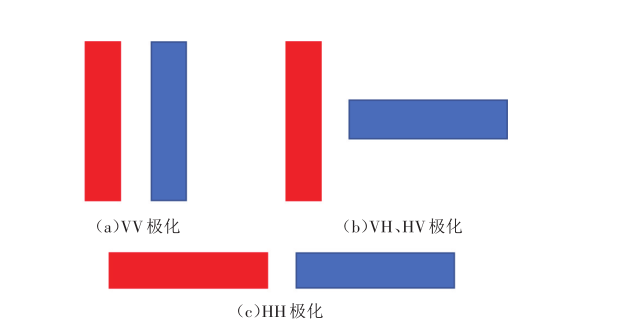
极化是描述电磁波电场矢端随时间变化情况的参量,反映了电场强度方向与入射面的关系。当电磁波的电场方向平行于入射面时为平行极化波(Horizontal polarization, H),电场方向垂直于入射面时为垂直极化波(Vertical polarized wave, V)。传统的探地雷达普遍采用单极化技术——仅发射并接收垂直极化波(VV极化),而全极化探地雷达则有4种天线组合方式,即同时发射并接收H, V极化波对目标体进行探测,从而获得VV, HH, VH和HV4种极化数据[7](如图1 所示)。由于收发天线作用可互换,故VH数据等同于HV数据。
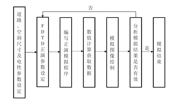
2 道路空洞全极化数值模拟
2.1 道路空洞数值模拟
为研究道路空洞的极化特征,首先结合实际道路情况建立数值模型,将模型(3.0m×3.0m×1.7m)按不同材料类型分为四层,参照《城市地下病害体综合探测与风险评估技术标准》(JGJ /T—2018)[12]选取各层材料参数,如表1 所示。根据表1 中材料参数建立道路空洞的数值模型。
表1 数值模型材料及参数 |
| 模型分层 | 介质材料 | 厚度 /m | 相对介电常数 | 电导率 /(S·m-1) |
|---|---|---|---|---|
| 空气层 | 空气 | 0.3 | 1 | 0 |
| 路面层 | 沥青 | 0.1 | 4 | 0.005 |
| 水稳层 | 水泥稳定碎石 | 0.4 | 9 | 0.05 |
| 土基层 | 土壤 | 1 | 10 | 0.1 |
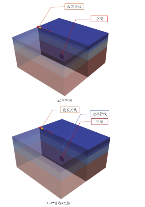
本模型计算考虑两种工况(见图3 )。工况1:路面下方1m模型中部位置存在一个底面直径0.3m、高0.4m的圆柱形空洞。工况2:路面下方0.5m模型中部位置存在一个底面直径0.2m、高0.4m的金属管线,金属管线正下方0.5m处存在一个底面直径0.3m、高0.4m的圆柱形空洞。模拟时选择400MHz雷达收发天线从(0, 1.5, 1.5)点沿X轴方向朝(3, 1.5, 1.5)点移动。
2.2 正演模拟结果
为提取数值模拟获取到的极化数据规律,本文采用振幅强度为主梯度来判别各种极化方式的探测效果。振幅通常是指电磁波电场强度的振幅,是反映电磁波能量强弱的物理量。在空洞探测过程中,地下介质相当于一个复杂的滤波器,电磁波信号传递至两种不同介质分界面时会发生强烈的反射波振幅变化,其反射系数R与两种介质的相对介电常数有关,如式(1)所示。两种材料的相对介电常数差异越大,则反射信号越强,产生的反射波振幅也就越大[13]。
式(1)中: 为介质1的相对介电常数; 为介质2的相对介电常数。
2.2.1 单空洞模拟结果分析
由于GprMax在进行三维模拟时,收发天线间的直达波振幅强度远大于穿越介质材料的入射波振幅强度[14],且电磁波在各层材料间传播特征对空洞分析存在干扰,因此本文在分析空洞图像前对原始数据中的直达波及各层间波形进行了处理,仅保留了空洞处的电磁波振幅特征,单空洞数据处理后3种极化方式下的空洞图像如图4 所示。
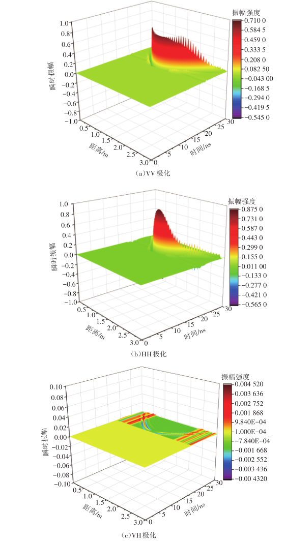
结合空洞在模型中的实际位置可以判断出图像中的双曲线即为空洞产生的电磁波回波信号。对于道路下方的独立空洞,VV极化和HH极化图像特征较为接近。当电磁波传播至空洞表面时,由于土基层材料与空洞的介电常数差异较大,由式(1)可知此时天线接收到的反射波强度会发生明显变化,在图像上表现为电磁波振幅达到顶峰最大值,之后随着电磁波继续向下传播,振幅缓慢减弱。天线距离空洞越近,电磁波振幅则越强。对于VV极化,振幅增长较为稳定,当天线接近空洞附近时不再变化,据此可判断空洞尺寸;而对于HH极化,电磁波振幅前期增长较慢,在靠近空洞附近后振幅才迅速增大至峰值,表明水平极化波对空洞周边区域影响较小、干扰性低。此外,虽然VH收发天线存在反射波抑制作用,接收到的电磁波信号较弱,但仍可辨识出空洞产生的抛物线形回波,且回波在空洞区域处发生断裂,可辅助判别空洞尺寸。
2.2.2 “管线+空洞”模拟结果分析
对原始数据中的直达波及各层间波形进行处理,仅保留空洞处的电磁波振幅特征,3种“管线+空洞”极化数据对应的空洞图像如图5 所示。
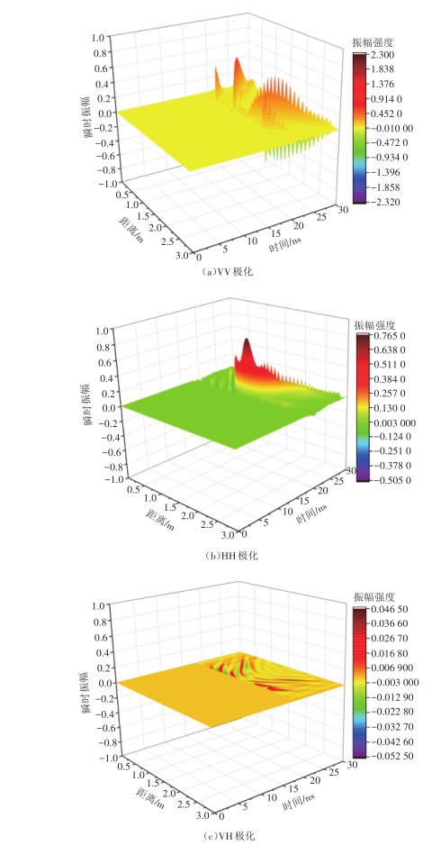
由图5 可知,当空洞位于金属管线下方时,由于金属介电常数极大,此时电磁波难以透射。将两组“管线+空洞”极化图像分别与单空洞图像对比发现:VV极化在中心空洞处的峰值振幅特征消失,空洞处电场强度较低;HH极化在中心空洞处仍存在峰值振幅,但振幅强度比单空洞小,且双曲线图像上的振幅存在突变。这是由于管线在垂直方向上尺寸较大,VV极化时电磁波无法向下传播,表现为管线位置反射信号极强、管线下方反射信号极弱,此时无法获取管线下方空洞信息。对于HH极化,由于管线在水平方向上尺寸较小,部分电磁波可绕射过金属管线表面进而探测到下方空洞信息,因此在HH极化图像上仍可清晰辨识出空洞位置。从图5 (c)可以看出,由于金属管干扰信号过强、交叉极化对空洞电磁波信号抑制作用明显,此时难以从VH图像上判别空洞特征,表明交叉极化不能适用于复杂环境下的空洞探测。据此可判断,在实际应用中仅从某一单极化图像上难以获取未知空洞的完整、有效信息。
3 道路空洞全极化数据融合
数据融合技术是一种处理多组相关性数据的有效方法[15]。本文中,GprMax计算获取的VV、HH、VH三组全极化数据是融合的基础,通过数据融合方法可提取出繁多数据中的主要图像特征,进而提高目标体识别能力。目前常用加权平均融合方法(Weighted Averaging, WA)进行数据融合,其公式为:
式(2)中: , , 为平衡三种极化数据的权重系数; , , 为由GprMax获取的极化数据矩阵。
可以看出,加权平均融合法具有简单易实现、运算速度快的优点,然而该方法削弱了图像中的细节信息,一定程度上会使边缘信息变得模糊,在多数应用场合难以取得满意的融合效果[7]。本文选用主成分分析融合法(Principal Component Analysis, PCA)进行全极化雷达数据融合处理。
3.1 全极化数据主成分分析融合
主成分分析(PCA)是指利用数学降维的思想,在损失很少信息的前提下,通过转化生成几个综合变量来代替原来的众多数据,进而在新的综合变量基础上进一步统计分析,转化生成的综合变量即为主成分[16]。
对于探地雷达获取到的全极化数据 ,用主成分分析法进行融合时步骤如下:
(1)数据降维处理。假设 , , 均为M×N矩阵,可分别将各矩阵中的2~N列数据依次放到第1列数据下方得到3个MN维列向量,再将三组列向量中的数据进行融合,便可得到一个包含了所有极化数据的MN×3矩阵,可表示为:
(2)取均值计算。将式(3)中的3列数据相加求平均值,可得:
(3)构建矩阵B的相关性矩阵C。令:
(4)利用线性代数方法求解式(6)相关性矩阵C的特征值,求取特征值 , , 及其对应的特征向量 , , 。成分Y可由B和 相乘得到,即:
(5)选取式(7)中最大特征值 对应的特征向量 ,主成分 可以由B和 相乘得到,即: =B 。
(6)主成分 可表示为一个长度为MN的一维向量,再将其重新转化成一个M×N的矩阵Z,就是数据融合后的全极化矩阵。
3.2 全极化数据融合结果比较
将GprMax模拟得到的两组全极化数据按主成分分析法进行数据融合,经降维、去均值处理后,分别得到相关性矩阵 , ;最大特征值 , ;对应的特征向量 (0.707, 0.560, 0.014), (0.421, 0.827, 0.036),最终得到融合矩阵 , 数据值,将加权平均融合法获取的融合图像与主成分分析融合图像进行对比分析,分别如图6 、图7 所示。
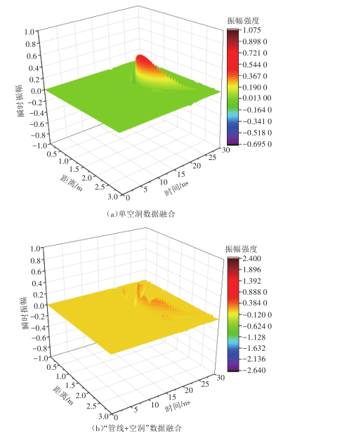
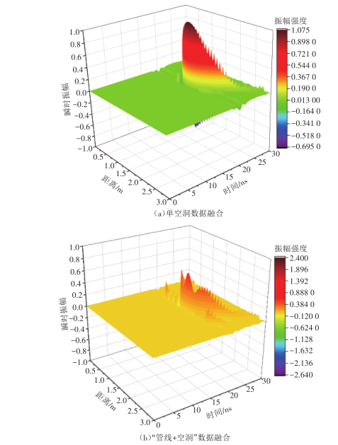
对比图6 、图7 可以看出,加权平均融合图像上的电磁波振幅相对较弱,与单极化图像相比振幅值降低,空洞特征极不明显。主成分分析融合法则可以得到清晰的空洞全极化融合图像,融合图像中包含了空洞在各极化图像中的主要特征。对于单空洞融合图像,融合后的电磁波振幅峰值在空洞处进一步增大,表明空洞的回波信号得到明显增强,同时振幅梯度波动范围集中,表明空洞对周边区域电磁干扰范围较小,这些均有利于清晰辨识出空洞位置。对于“管线+空洞”融合图像,数据融合后金属管线对空洞信号仍存在干扰作用,表现为振幅峰值仍存在起伏变化,但空洞处已出现明显振幅峰值,从图像上足以辨识出空洞的回波信息,表明融合图像中金属管线对空洞信号的屏蔽作用有所削弱,全极化融合技术提升了复杂环境下地下空洞的探测与识别能力。
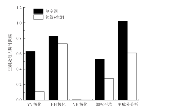
继续选取空洞的振幅最大值进一步比较,如图8 所示。可以看出:在理想的单空洞状态下,加权平均融合后的最大振幅较VV极化、HH极化均有所减弱,而主成分分析融合后的最大振幅值较单极化时分别提升了约60%(VV极化)和20%(HH极化),这表明经过主成分分析数据融合后的单空洞波形变化更加明显,雷达图像的分辨率显著提高;在“管线+空洞”条件下,加权平均融合后的最大振幅值较VV极化时提高了1倍,但仍远小于HH极化振幅值,而主成分分析融合图像的最大振幅值较VV极化时提高了5倍,较HH极化则降低了约20%,此时VV极化的空洞振幅特征已全部失效,受VV极化影响,融合图像上的空洞振幅强度也较HH极化时有所削弱,但仍能观测到明显的振幅变化。
实际复杂工况环境下,空洞常伴随地下管线等构筑物存在,材料参数的差异致使单极化数据不具备代表性。主成分分析融合法充分集合了地下空洞的几何图像特征和不同的散射极化信息,能得到更真实、更高分辨率的探地雷达图像,可以满足不同散射机制环境下的道路空洞探测要求,更有利于实际应用中空洞图像的辨识。
4 结语
本文在理论分析的基础上,利用GprMax软件建立了道路空洞数值模型,获取到理想化状态下的道路空洞极化数据。然而仅从单极化图像上难以获取完整、有效的空洞信息,为此本文继续选用主成分分析法提取、融合了原始数据中的极化特征,得到了分辨率更高的全极化融合雷达图像。将融合图像上的振幅最大值分别与初始极化图像的振幅最大值进行比对,发现单空洞条件下主成分分析融合后的振幅最大值分别提升了约60%(VV极化)、20%(HH极化),融合后的空洞图像分辨率得到显著提高;“管线+空洞”条件下,主成分分析融合图像上的振幅最大值较VV极化时提高了5倍,较HH极化则降低了约20%,此时VV极化振幅已全部失效,融合图像振幅受此影响也较HH极化时有所削弱,但仍能观测到融合图像上空洞振幅的明显变化。以上分析表明,融合后的图像中集合了道路空洞的不同几何图像特征和多种散射极化信息,能更加合理、准确地对极化数据进行解译,主成分分析法满足了不同散射机制环境下的道路空洞探测要求,进一步发挥了全极化探地雷达的探测优势。
本文仅选用主成分分析法对雷达图像进行融合,随着全极化探地雷达与图像处理技术的发展,后续研究可尝试采用更多种融合方法对雷达数据进行融合处理,探索更深入、更适合的雷达图像融合方法;同时,本文所选用数据融合方法仅是在极化图像的基础上进行融合,后续研究可尝试从电磁波原理等角度开展数据融合研究。


